It was a Sunday afternoon inside one of the colossal, cool, half-dark room of the Fort St. George museum at Chennai. Perhaps it’s the only place where I felt the existence of soft winter in entire town during my visit. There, in the late afternoon light I was amazed to observe an early colonial map showing Pulicut as a flourished port town, which has reduced to a small fishing town now. The ambiguity of the room must have added to my surprise. The pale yellow tinted page had definitely sprung up my imagination to create an image of the fort city. How the artist imagined aerial view of the area in 17th century? I try to look into the city through the eye of the unknown map-maker… How far the image has changed in last three hundred years?
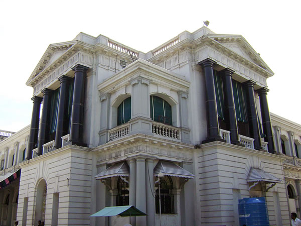
My fellow travel-mates, who came all the way from Japan for tracing the Dutch trade connection between Japan and India, were busy pointing at the fort, churches, and cemetery at Pulicut, the headquarter of Dutch Coromandel in 17th century. Comprised of a square structure with projection in its four corners, the structure of Fort Geldria is very similar to that of Fort St. George, though the earlier was essentially a Dutch one and the later-English.
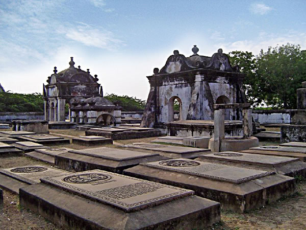
 When the next day we arrived at the site, no one could say us about the fort there except Mr Benedict. “There, across the moat…the whole fort area is covered under layers of thick bush”, as he explains the history almost comes alive in front of us. The fort was destructed during the Anglo-Mysore war and then by the British. Around the fort area, irregular settlements came up over the ages. Adjacent to the bus stop, appears the “new” Dutch cemetery (which was in use from 17th century). The gateway, with an arch and intricately carved skeletons in both the sides had certainly shocked me out. Last few months, I was a visitor of temples and forts, where the doorways are guarded either by muscular guardians or sensuous river goddesses. Comprising of seventy seven graves, the cemetery is a land of astonishment! The tomb-stones, each carved with different themes and patterns have stories deep-buried about their time, patronisers and obviously the artists. According to Mr Benedict, some stones might have been carved in this region, which show the ease of dealing with Indian design patterns. One of the tombstones carved out of black granite, has a syncretic image of cherubs with earthen lamps in their hand. I wonder how the communication between two distant countries had resulted in creation of these imageries. While our way back to Chennai, I observed the pot-bellied, fierce-looking guardian sculptures with earthen lamps in their hand, placed over the roof of temples.
AARDE foundation has a small, well-maintained interpretation centre there, few steps ahead the cemetery. A number of objects including pieces of pottery, glass jars, maps, and an intact bed, collected from the neighbourhood. Definite evidences of Dutch trade in Coromandel, lot of these objects were accidental find. The earthen jars were used for storing crops or water, even somewhere as garbage bin. The bed was lying in a household, who were looking for replacing it with a new one. The ultramarine blue glass jars have their ancestry in Middle East. The most interesting for me was a map. Very similar to what I found in Chennai, the map is etched and hand coloured, manufactured in 18th century, showing a very different Pulicut from what I see today. Local members of the organization do basketry and mat-weaving during the off-time which partially support them financially and also keeping the local craft practice alive.
 A short tour through the roads around fort area was full of exploration. Portuguese and Dutch churches and houses share space with their Indian neighbours here. St. Anthony’s church, a white-and-blue structure, in the bright sunny day and middle of a fishermen’s settlement looked altogether an alien. Inside the double folded blue doors, there’s a small hall-cum-store room. A wooden chariot with cylindrical base and pyramidal roof was kept there, possibly for the processional purpose. What a shared culture we belong to! Similar chariots in larger scale are part of almost every Hindu temple in this part of the country, which serve similar purpose.
Finally we entered fort area (though only the name remains) facing the blue Pulicut lake. Reminiscent of the golden era of this port town, an old house remains in the fort area (or perhaps the only house). With simple Doric pillars supporting the slanted tiled roof, the house was once used as a trading post. Now the house is situated in compound of the local health centre. Health of these falling houses and architecture needs to be taken care of. In the night, the cemeteries are dug up for seeking hidden treasure, which, if not anything else, destroying these structures. A navy blue blue board with “protected monument” written over were seen more than one places, I hope the words come true in near future.
Often majestic trade ships are drawn in the maps. In the blue lake before my eyes, I see spindle-shaped boats, made out of tree trunks. The simple engineering of making them are continuing till ages, from long before the trade ships reached this land. While the map-maker was busy documenting the grand ones, the small ones got ignored. Through the passage of history, these modest fishing boats made its way, which the grand ones had failed. I decide making a map based on my experience; is this the way they started thinking? But I shouldn’t forget to draw the bunch of lively boats beside the lost landscape!
Rajarshi Sengupta